The Borgsumburg on the North Frisian island Föhr


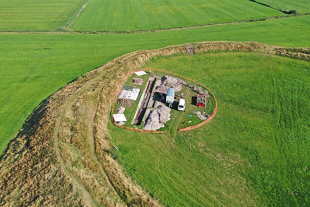
Located about 1 km north the village Borgsum on a moderate raised moraine crest, a circular rampart, visible from afar, still bears witness to the monument preserved above ground. The Borgsumburg on the North Frisian island Föhr has a height of nearly 8 m and an inner diameter of almost 100 m. Excavations in the 1950s uncovered parts of several well-preserved buildings with sod walls in the inner area, which can be dated to the period from the 8th to the 11th century. Geomagnetic and -radar surveys in 2001 and 2003 revealed further remains of numerous, closely spaced sod buildings along the inside of the circular fortification. Thus showing that the inner development of the imposing monument is conspicuously uniformly radial.
The importance of the Borgsumburg is also underlined by the results of the preceding DFG-funded project "Gewerbewurten und Geestrandhäfen - mittelalterliche Handelshäfen an der deutschen Nordseeküste" (Gewerbewurten and Geestrand Ports - Medieval Trading Ports on the German North Sea Coast), which highlighted the early medieval settlement landscape around the castle (Majchczack 2020).
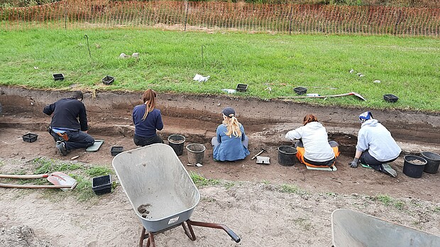
Both dating and use still raise many questions. Since June 2021, a four-year project funded by the Frederik Paulsen Foundation under the direction of Dr. Martin Segschneider has been investigating the interior of the Borgsumburg according to current questions based on archaeological excavations, pedological investigations and botanical analyses. The research assistant and excavation director is Dr. Kirsten Hüser.
In addition to the research within the borders of the early medieval rampart, the surrounding area is being investigated geoarchaeologically and paleotopographically since February 2022 by Pière Leon Frederiks (M.Sc.), research assistant and PhD student, as part of his thesis in cooperation with the Institute for Ecosystem Research at Christian-Albrechts-University Kiel under the supervision of Prof. Dr. Eileen Eckmeier.

Investigations within the castle complex
The inner area of the monument will be studied in more detail in several excavation campaigns in combination with natural science and various dating methods. Therefore, an accurate overview of the multiphase time of use as well as the definite abandonment of the complex shall be elaborated. Furthermore, questions concerning the origin of the castle and its integration into the surrounding cultural landscape as well as clues concerning the builders and the life in the castle are to be clarified based on find material.
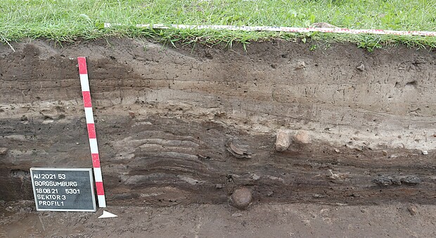
The first excavation campaign during the summer of 2021 already yielded the first exciting results of the uppermost phases of use. The assumption that the sod houses were constructed close to each other radially inside the circular rampart as seen on the geomagnetic and geo-radar images can now be confirmed. In addition to the orientation and positioning of the inner buildings, new results on the structure and the use of the houses itself could be obtained. The excavations yielded, in addition to period-typical utilitarian pottery, four glass beads and a well-preserved pot of 10th-century wheel-thrown pottery from Haithabu.

In between moraine, marsh and sea
During the archaeological excavation in 2021, the interest concerning the landscape as well as natural waters adjacent to the rampart emerged and evolved into a PhD thesis. Therefore, the research focuses on geoarchaeological and paleotopographical beyond the boundaries of the early medieval castle complex.
Through incorporating newly gathered data with the current state of research a profound foundation for analysis and interpretation of the landscape genesis, natural waters and development/ usage of the marshlands is aspired.
Different geophysical and –botanical methods will be applied in order to gather more in-depth information of the fossil surface soil formation. As an example, geomagnetic survey and the extraction of coring samples to obtain an overview of the stratigraphy beneath the marshland are planned as initial measures. Additionally it is intended to document the aerial perspective of the study region by using a drone to map potential vegetation anomalies.
References
- Majchczack, B. S., 2020: Die Rolle der nordfriesischen Inseln im frühmittelalterlichen Kommuniktationsnetzwerk. Band 1 und 2. Rahden/Westfalen.
- La Baume, P., 1961: Was wissen wir über die Lembecksburg? Museumsverein Insel Föhr e. V., 16 S.
- Majchczack, B., Schneider, S., Wunderlich, T., Wilken, D., Rabbel, W., & Segschneider, M., 2018: Early Medival trading sites on the North Frisian Island of Föhr. In: v. Carnap-Bornheim, C., Daim, F., Ettel, P., Warnke, U., (eds.) Harbours as objects of interdisciplinary research. Archaeology + History + Geosciences, RGZM-Tagungen 34, 311–328.
- Segschneider, M. (Hrsg.), 2009: Ringwälle und verwandte Strukturen des ersten Jahrtausends n. Chr. an Nord- und Ostsee. Internationales Symposium Utersum/Föhr 2005. Neumünster.
- Stümpel, H., u. Erkul, E., 2009: Geophysikalische Prospektion der Borgsumburg. In: M. Segschneider 2009, 113-121.
